➞ Back to Index of Maps.
This sequence of maps takes you through the development of the political geography of the region.
You can download individual maps or download the complete package of maps which includes all the maps below plus an additional 9 maps. This is a 10.5 MB file so it may take a while unless you have high speed broadband.
 © mideastweb.org © mideastweb.org |
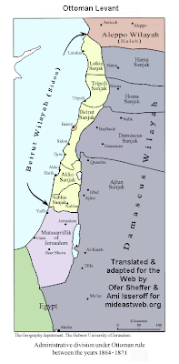
Pre 1918
The area now known as Israel, the West Bank, Gaza and Jordan was very different during the period of the Ottoman Empire. For 500 years a middle east feudal aristocracy controlled the vast tracts of land and the peasant farmers who lived there. There were no nation-states during this era. No Israel, no Palestine, and little of the nationalist ideologies of the 20th century. |
 © PASSIA – Palestinian Academic Society for the Study of International Affairs © PASSIA – Palestinian Academic Society for the Study of International Affairs |
1918-1948
Since the Ottomans sided with the Germans during World War 1, they naturally lost their empire to the Western Allies who soon chopped it up into spheres of control.
|
 © ICAHD – Israeli Committee Against House Demolitions © ICAHD – Israeli Committee Against House Demolitions |
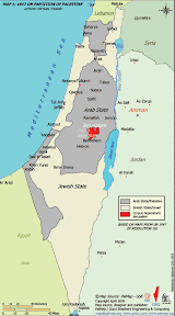
1947
During 1947, and the British were preparing to leave Palestine, the new United Nations debated the issues and finally published this map to divide the territory between a Jewish and Arab state. This proposal was never implemented
|
 © ICAHD – Israeli Committee Against House Demolitions © ICAHD – Israeli Committee Against House Demolitions |
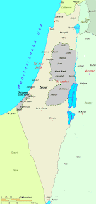
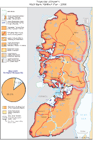
1948-1967
During the war of May 1948 Israel conquered 22% more territory than had been allocated under the Partition Plan. This territory, about 78% of Western Palestine became the state of Israel, based on the 1948 cease fire line,known today as the Green Line
|
 © ICAHD – Israeli Committee Against House Demolitions © ICAHD – Israeli Committee Against House Demolitions |
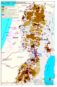
1967-2009
In 1967 Israel conquered the West Bank and Gaza and began settling Jewish Israeli citizens in the territory. In 2006 Israel withdrew all settlers from Gaza and sealed the area. Palestinians became confined to cantons in the West Bank as the numbers of settlers increased to over 500,000 by 2009.
|
 © Negotiations Affairs Department – Palestinian Authority © Negotiations Affairs Department – Palestinian Authority |
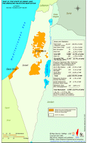
2000
At the Camp David talks of 2000 Israel presented this map as a take it or leave it proposition, also refusing to discuss the sharing of Jerusalem or a resolution to the refugee issue President Arafat refused since the West Bank would then be divided into three pieces, with no control of the eastern border with Jordan
|
 © ICAHD – Israeli Committee Against House Demolitions © ICAHD – Israeli Committee Against House Demolitions |
2009
The West Bank Palestinian cantons hardened after the first Netanyahu administration in the late 1990s Walls and fences were built to contain Palestinians inside ghettos while Israel expanded the settlements and built segregated roads throughout the West Bank
|
 © FMEP – Foundation for Middle East Peace |
2008-9
The segregated Arab-only roads in the West Bank connect the Palestinian cantons through tunnels underneath the exclusive Israeli-only roads that connect the settlements to each other and to Israel.
|
Download the complete package of maps, including 9 more – 10.5MB
* Please note that these maps have various copyright holders, as noted, who should be credited if the maps are published elsewhere.
➞ Back to Index of Maps.
Comment (0)